From Environmental and Energy Data to Sustainable Decisions
From precipitation and flooding to energy consumption to heat islands: resource and environmental issues affect every municipality. Citymonitor helps to systematically collect, evaluate and make these usable for decisions.
Environmental and Energy Data Are Distributed and Difficult to Use Together
In the areas of environment and energy, data is generated in many different places – sometimes not yet collected, sometimes sporadically, sometimes in existing internal and external systems. This diversity makes it difficult to combine information and prepare it in such a way that it is usable across departments in municipal everyday life.
Typical Consequences in Municipal Everyday Life
Overview and Decision Basis for Planners and Emergency Services
Citymonitor supports municipalities with various packages to make environmental and energy topics usable across departments. This creates a common view of current developments for planners and emergency services – as a basis for quick reactions, well-founded decisions and the further use of information in other application areas.
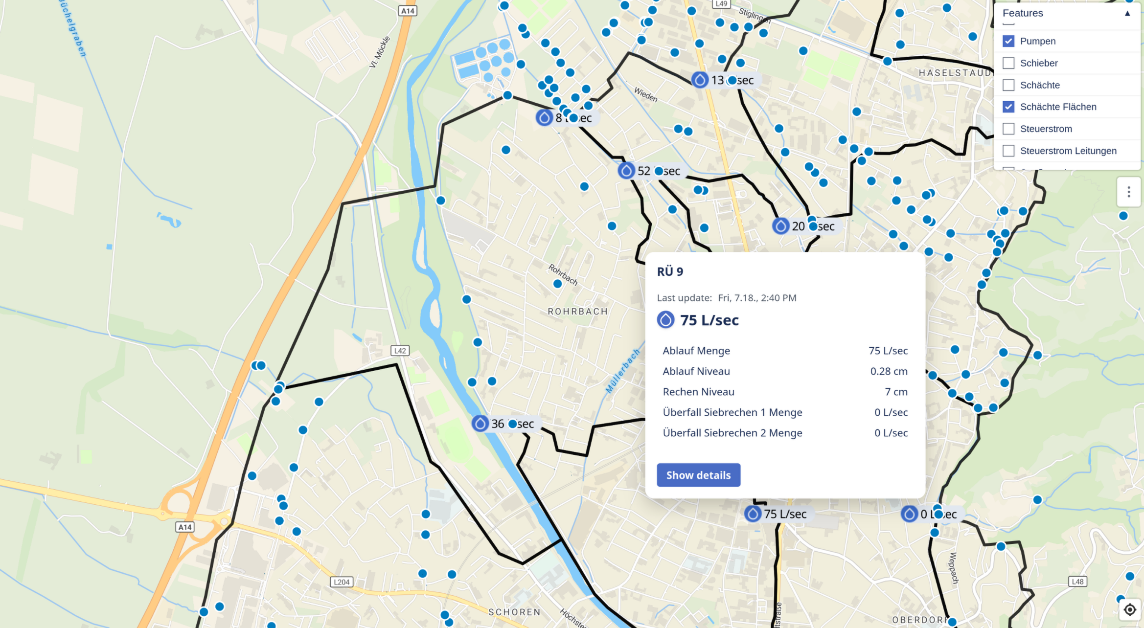
Map displays and GIS information for a current situation overview
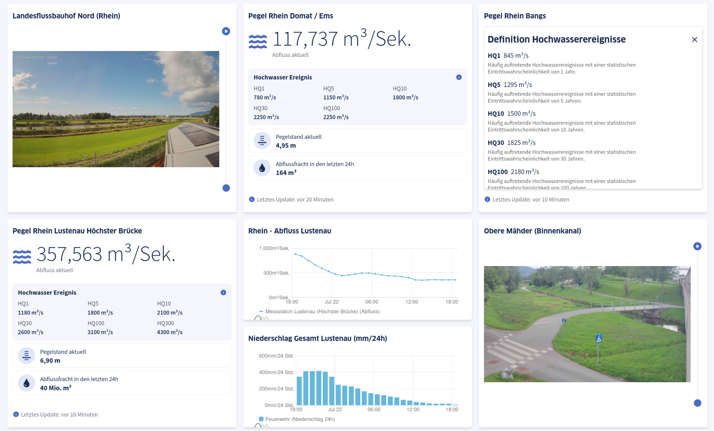
The current flood situation always under control
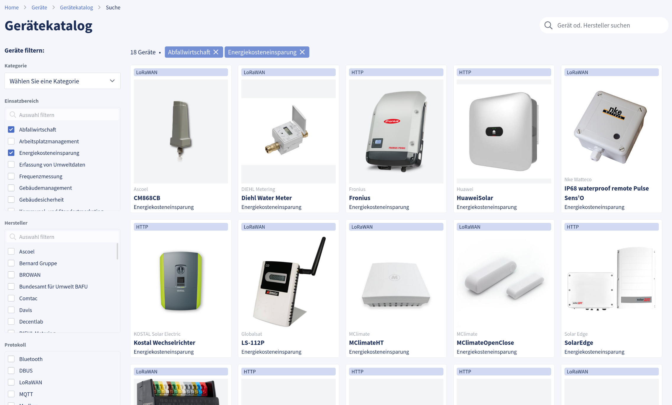
An extensive device catalog and numerous interfaces for connecting data sources
Selected Packages for Key Use Cases
Recognize Current Situation, React Early and Secure Decisions
The package creates an ongoing overview of precipitation, water levels and discharge developments. Planners and emergency services receive a common situational overview that supports quick reactions in the event of an emergency as well as well-founded decisions in prevention and climate adaptation.
Common Situation Assessment
Classify current developments across departments – instead of isolated individual information
Response Capability in Event Situations
Recognize critical situations early through forecasts and react specifically
Reliable Decision Basis
Track developments over time and plan measures based on facts
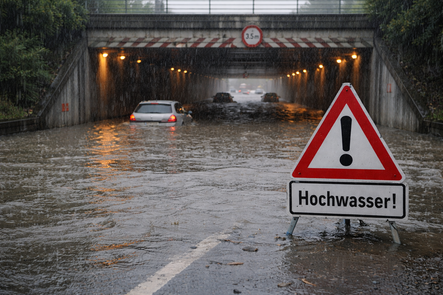
Challenge
Data on precipitation, water levels and discharge is generated in different places – in existing systems, at individual measuring points or project-related.
In the event of an emergency, it is time-consuming to consolidate this information, keep it up to date and make it usable for different actors.
Approach
Citymonitor consolidates relevant data sources on precipitation and discharge, continuously displays developments and creates a common situational overview. Critical developments are recognized early and can be passed on specifically.
This Enables
- Ongoing overview of precipitation, levels and discharge developments
- Early detection of critical situations
- Targeted alerting and information
- Traceable time series for prevention and evaluation
Particularly Relevant For
Emergency Services & Operations
- Early hints in case of critical developments
- Support for situation assessment and coordination
Urban Planning & Climate Adaptation
- Foundations for measures such as water retention or sponge city
- Assessment of developments over time
Citizens
- Understandable information in critical situations
Further Use
- Transfer of information to citizen information or emergency systems
- Export and use in other applications
- Combination with other environmental and climate data
Practical Example
Digital Flood Protection in Dornbirn
→ To Case Study
Make Heat Visible and Control Measures Specifically
The package supports municipalities in presenting heat stress in the urban area in a comprehensible way. It shows where stresses arise, how they develop and where measures are effective – as a basis for planning, health protection and communication.

Spatial Classification
Recognize hotspots on real-time heat maps and track with measurements
Analyze Developments
Historical data and future forecasts make needs visible
Protect Risk Groups
Vulnerable groups can be warned early through forecasts
Challenge
Heat stress is increasing in cities but acts very differently spatially.
Without continuous observation, it is difficult to identify hotspots, plan measures specifically and evaluate their effect comprehensibly.
Approach
Citymonitor makes heat stress visible by consolidating different data sources and presenting them understandably. Developments can be classified spatially and temporally.
This Enables
- Identification of heat hotspots in the urban area
- Comparison of stresses over time
- Assessment of the effect of measures
- Support in prioritizing climate adaptation measures
Particularly Relevant For
Urban Planning & Environmental Departments
- Decision bases for greening, unsealing and urban development
Health & Social Services
- Support for heat action plans
- Protection of vulnerable groups
Public
- Transparent information about heat and cool places
Further Use
- Use in reports and funding programs
- Transfer to citizen information
- Combination with other environmental and climate data
Make Energy Yields Transparent and Actively Control
The package provides a central view of photovoltaic systems and relevant energy data. It supports comparing yields, recognizing developments and controlling investments and operations in a well-founded manner.

Create Overview
All systems and developments in a common view
Enable Optimization
Recognize deviations and potentials early
Secure Decisions
Transparency for administration, politics and public
Challenge
Municipalities are increasingly investing in photovoltaics and energy projects.
Without an ongoing overview, yields, deviations and optimization potentials often remain unclear.
Approach
Citymonitor creates a common view of relevant energy data and makes developments traceable over time. This enables systems and measures to be actively monitored.
This Enables
- Central overview of PV systems and energy data
- Comparison of yields and developments
- Recognition of deviations and potentials
- Sound basis for operations and planning
Particularly Relevant For
Energy Management & Property Administration
- Transparency about yields and usage
- Support for operations and maintenance
Administration & Politics
- Traceable decision bases
- Transparency towards the public
Further Use
- Combination with consumption and heat data
- Use in energy and climate reports
- Connection to other application areas
Additional Packages in the Environment and Energy Area:
Air & Noise
Detection of particulate matter, NO₂, noise and other environmental parameters for healthier cities and data-based traffic planning.
Tree Health
Sensors for optimal irrigation, protection against drought damage, efficient care of public green spaces, tree health.
Water Consumption & Resource Management
Monitoring of drinking water and wastewater networks, early detection of leaks, basis for sustainable resource use.
Energy Consumption
Combine and evaluate real-time data from smart meters, existing meters and manual readings.
... and many more.
Feel free to contact us for additional packages or customized solutions!
Schedule Demo NowWhere Measurable Value Emerges
Better Planning
For Strategic Decisions- Prioritize investments specifically – based on reliable long-term data
- Track developments over years (environment, energy, infrastructure)
- Demonstrate effectiveness of measures and systems measurably
Faster Response
For Operations & Maintenance- Identify currently affected areas and systems
- Recognize failures, deviations and critical developments early
- Deploy resources, maintenance and personnel specifically
Informed Citizens
For Trust & Transparency- Communicate developments and measures understandably
- Present energy, environmental and climate topics comprehensibly
- Strengthen trust through open, data-based information


Curious to Learn More?
We would be happy to discuss together which of the shown approaches make sense for your municipality and what a pragmatic entry could look like.
Needs Assessment
What are your current challenges?
Inventory
Which data sources and systems already exist?
Prioritization
Where is the greatest leverage for quick successes?
Implementation
Step by step, without creating dependencies